
Know that weird section of the city just south of I-64 from roughly Vandeventer to the Mississippi River? That uninhabited, rail yard-laden, abandoned landscape is sparse at best to a major barrier at worst. The rails and lack of residential are an impediment to a contiguous flow from the central corridor into south city.
So it's exciting that this part of town, including Downtown, Downtown West, Midtown and the Central West End is planning a makeover of sorts being led by Great Rivers Greenway (GRG).
“Great Rivers Greenway, along with many partners, is holding a design competition to envision the CHOUTEAU GREENWAY – a transformational project to connect Forest Park to the Arch, with spurs north and south to connect our city’s vibrant neighborhoods, parks, business and arts districts, employment centers, transit and dozens of cultural and educational institutions together.”

The ambitious project has been in planning for nearly 20 years in one form or another. And, the Chouteau Greenway Design Competition is the latest step to bring a long-time vision to life. The process has taken 10-months, culminating with the submissions from four talented design teams.
The following four teams were selected from a total pool of 19 submitted proposals:
- James Corner Field Operations in association with [dtls], WSP, HR & A Advisors, Lord Cultural Resources, Sherwood Design Engineers, MIC, L’Observatorie, ETM Associates
- STOSS Landscape Urbanism in association with Amanda Williams, Urban Planning and Design for the American City, Alta Planning + Design, Marlon Blackwell Architects, HR & A Advisors and David Mason and Associates
- TLS Landscape Architecture, OBJECT TERRITORIES, [dhd] derek hoeferlin design in association with Langan, Linda Samuels, Paola Serrano, EDSI, Ramboll, Kristin Fleischmann Brewer, eDesign Dynamics, Silman, Econsult Solutions, Bryan Cave, Preservation Research Office
- W Architecture & Landscape Architecture in association with Arup, ABNA Engineering, Gardiner & Theobald, Kiku Obata & Co., Regina Myer
You can read all about the design goals set forth for the project HERE.
On May 2, GRG announced Stoss Landscape Urbanism was unanimously selected as the team to proceed with the design. The next steps include a series of workshops, where the Stoss team will review the community input gathered thus far and work with project partners to further refine their conceptual plans. Per GRG, this phase is expected to take several months and will provide the opportunity to develop specific greenway corridors, connections, and concepts. Once the overall plan is in place, projects will undergo further community engagement, feasibility and alignment studies, design work and engineering before beginning construction. (source)
The jury selecting Stoss published their full report HERE. Keep in mind, elements from all four proposals may be incorporated into the final plans and the plan could look completely different than what's in their winning proposal, but Stoss will be the team leading the effort in the next stages.
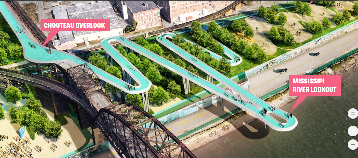
Some of the most eye-catching elements of the proposal include a river overlook between the Poplar Street and MacArthur Bridges, with a landscaped park along the graffiti wall.

Looking east from Forest Park, there is an elaborate pedestrian connection over Kingshighway connecting the Central West End to the park. If realized, this would become an iconic place on our city's west end.


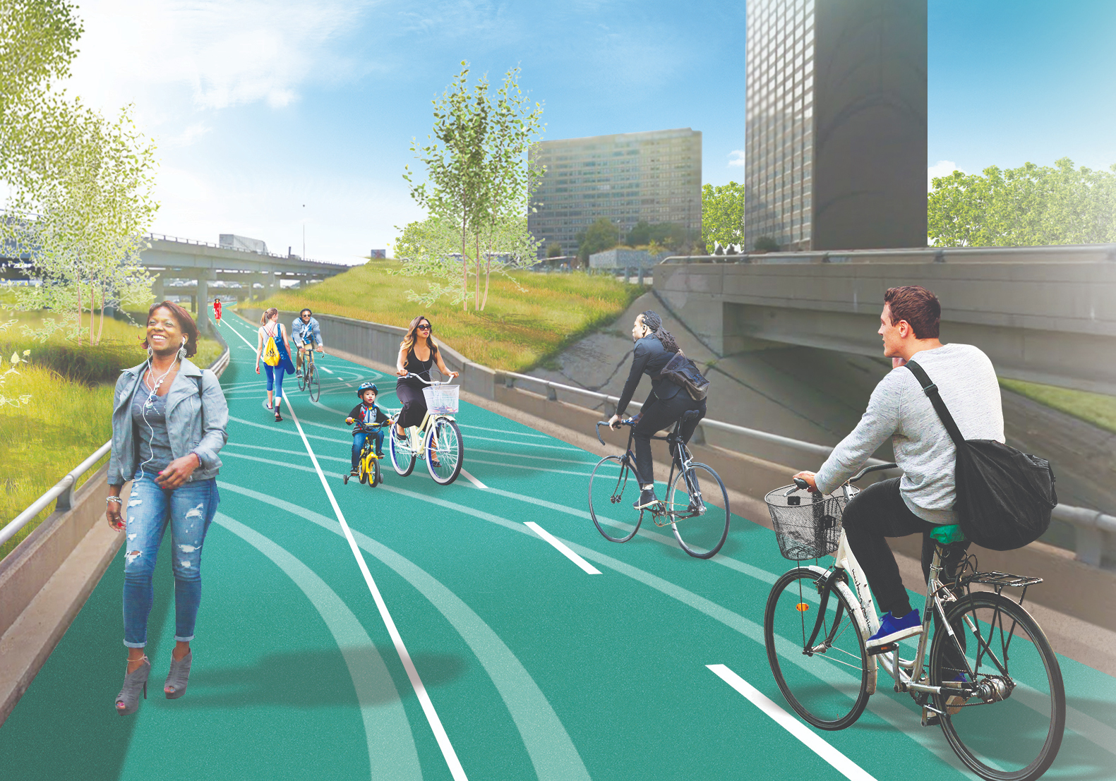
Very complicated areas including the overpass ramps related to I-64 and the Compton Avenue bridges just south of Harris-Stowe University are connected through a series of landscaped paths allowing pedestrians to get through some current dead zone areas of the city.

This area was dubbed Bowtie Eco-Park because this is where the south path leading from Chouteau's Landing crosses with the north path that skirts Market Street from the Arch through downtown along the Gateway Mall.
The area up until 1959 called Mill Creek Valley around Market and 22nd Street is envisioned as a path north of Union Station, skirting the Gateway Mall all the way to the Arch.

Much of the dead space I previously mentioned in the areas around the railways is slated for prairies and greenspace, softening the sparce no man's land spots south of I-64.

The continguous route which criss-crosses at Bowtie Eco-Park is a massive loop around the Arch all the way to Forest Park. This is the element of the design that really appeals to me. There are plenty of opportunities to connect from neihborhoods both north and south of the central corridor route.
So with our bearings on the overall design, it was time to read about the jury selection of the Stoss plan.
Here are some of our thoughts on the jury's report.
First, the discourse of the discussion is a respectable one. The turn that St. Louis appears to have made in recent years is to consider equity and understanding and engagement of people who live here is impressive.
While the emphasis of the plan focuses on connections between the Arch and Forest Park, the plan was impressive in that it reveals some abandoned parts of the central corridor:
"With some placemaking, its emphasis can be more about connections and de-emphasizing the automobile. as a critical place to begin."
The jury provided some recommendations for refinement.
"Clarify the framework diagram. While the framework diagram is quite clear, it is deceptive and is not a good representation of the level of detail presented in the east/west corridor versus the north/south corridor. The graphic depiction over represents the north/south elements in the plan and may create false expectations."
I get this. The connections to the greenway from Grand and Tower Grove Avenue/Vandeventer make it seem like there will be tree-lined dedicated bike/walking lanes from Tower Grove Park and Fairground Park ; that seems ambitious as these are huge stretches. Creative and branded signage could likely serve the same purpose to get people to the greenway from the densely populated neighborhoods to the north and south.
"Align with critical economic nodes. The routes and connections should focus on the energy at NGA/22nd Street, Sarah Street, and the triangle of the Foundry, Armory, Cortex, and Grand Center. ‘Need some economic metrics’"
The continuing evolution of Cortex and the $1.75B investment in the new NGA campus in North City has to be priorities for the city. We have to cater to these job hubs and get people easily connected to the Arch and Forest Park via the greenway. Downtown St. Louis and the Central West End are a couple of the rare neighborhoods to show increases in population in the 2010 Census. We need these residential areas biking to the Foundry/Armory/Cortex, etc. in "the middle".
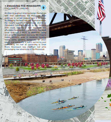
"Make a realistic river connection. Find ways to make the connection without touching the MacArthur Bridge or river levees. Also, reaching south of the Arch grounds is laudable, but this location and particular solution is not a priority. When the time comes to study this opportunity, the design could develop around the principles presented."
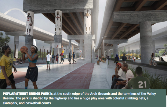
I disagree that extending south of the Arch is not a priority. I think the focus needs to be this and this and the Forest Park entrance over Kingshighway. These are the bookends that make this project a placemaker. The winding finger over the river in the Stoss plan does just that. The design from James Corner Field Operations (below in the upper right) was the most ambitious with a double deck path flanking the MacArthur Bridge, but touching the bridges appeared to be a show stopper for the jury. The TLS Landscape proposal for the Riverfront was underwhelming and requires re-engineering of flood walls and flow of the river (below, lower left) and the W. Architecture and Landscape Architecture proposal was a park right by the river (below, bottom right). While a bit of a concern because there is very little residential in this part of the city, a series of basketball courts in a under-Interstate ramp just seems so damn cool.

"Improve the environmental strategy. Significant improvements should be made to the ecology and hydrology strategies. In agreement with the TAG, the Jury agrees that the sustainable aspects are lacking in this plan. This is not only an issue of environmental protection and sustainability, but is also an economic development and real estate issue. Incorporating stormwater management infrastructure into the framework can lessen development costs to encourage development."
Here, here! This is a sustainability issue that the city will get saddled with if not comprehensibly addressed now...in the planning. This may not be a glamorous element of a design, but it is so important. This is why I trust GRG as a steward of our tax dollars and the city/region. They think of this and remind everyone of the importance of infrastructure. They are thinking of future development potential, which all starts with good flood/storm water control. Thanks all.
The jury continued with a series of strengths and weaknesses observed. Here are a few key elements of the strengths from our purview:
* has a strong spine and east/west connections
* easy to visualize
* the north/south strategy for vacant lots is appropriate, proposing some commitments without large new infrastructure
* might actually encourage people to the western edge...a major art project representing the Mill Creek Valley community is inspiring
And then some keys on the weaknesses:
* over promises north/south actions, appearing skewed to promote the north/south axis
* north/south routes seem to be in the wrong location
* concerns about the return on investment of the land bridge to Forest Park
* goes beyond what was asked on the riverfront, but it is an over reach and not a priority at this time
* not a strong enough strategy for ecology and hydrology, sandblasted concrete does not seem to be maintainable.
I disagree on the location of the north/south connections. It has to be Grand and maybe instead of Vandeventer, Compton or Jefferson would be better. Jefferson is WAY too wide and needs a diet that this project could help with that, especially if a streetcar ever came to be on Jefferson.
Also disagree on the land bridge to Forest Park and emphisis on Mississippi River connections. What? Sure these will be expensive and drastic. But, dammit, we need dramatic bookends. This is a chance to be a National icon. Kingshighway is a deathtrap for pedestrians. There is no reminder that people are welcome on Kingshighway, this would be it! Also, many criticize St. Louis for not making meaningful connections with the river. Memphis, Louisville, Cincy, Chicago...other city's do it. The path/finger extending over the River does just this...allows us to connect with the river and focuses on the MacArthur, not the boring PSB.
I'm disappointed this is not held as a priority, and hopefully we can compromise on these two elements.
The criticism and praise of the other three proposals is righteous, I'll let you read through them. But, we can take elements of these, including:
* Hydrologic strategy is really inspired
* Good that transit is a part of the discussion—includes Metrolink in their framework
* Like the Y bridge would be a possible landmark element.
Yes, a waterway would be cool in addition to the kayaking and paddleboarding available in Forest Park. Think of the cost, though.
The Y Bridge is indeed cool and a more cost conscious effort vs. the Stoss proposal. I like that it's being considered.

Again, the full jury report can be accessed HERE.
This will be an interesting project to continue to track. There is plenty of activity on the horizon to keep you optimistic about the city's future.
This project is about connectivity and healthy living. Moulding our Industrial past into a new, healthier, high-profile city that takes the outdoors as serious as preservation of our world-class neighborhoods and architecture.
We continue to evolve into a more equitable city that takes into account pedestrians and residents...making connections through some currently challenging landscapes that will lead us to brighter, healthier days.
This is an opportunity to fix some of the grave planning mistakes from slum clearance of Mill Creek Valley to the butchering of city by the Interstate highway system.
This could be an iconic project that draws international attention to the latest chapter in our rich history.
Cheers to all the hard work and intelligent people investing their heart and soul into this equitable treatment of some key parts of our city! You are the key to the future.
